The South African Weather Service (SAWS) continues to closely monitor Tropical Cyclone Gezani, currently located in the Mozambique Channel.
Gezani, which developed over the south-west Indian Ocean to the east of Madagascar, made landfall over Madagascar as a tropical cyclone on Tuesday afternoon.
Environmental conditions
After moving inland, it weakened to an overland depression before entering the Mozambique Channel.
Upon entering the Mozambique Channel, where environmental conditions are favourable, the system intensified to tropical storm status and subsequently to tropical cyclone stage.
No threat to SA
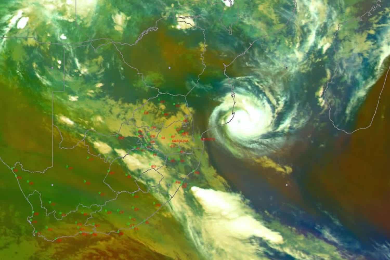
According to the Saws, the latest satellite imagery showed Gezani situated over the Mozambique Channel.
“The system remains well-defined, with organised convective cloud bands concentrated around its centre. In RSA, cloudy & cool conditions are observed in the east, with active isolated to scattered thundershowers,” Saws said.
“There remains no direct threat to South Africa at this stage.”
ALSO READ: What’s up with the weather? KZN residents warned of severe thunderstorms after heatwave
Mozambique
In the latest update, Saws said Gezani is currently over the south coast of Mozambique, and is forecasted to move back into the Indian Ocean.
“A well-defined Tropical Cyclone “Gezani” was situated just off the coast of Mozambique earlier this morning [Saturday]. The centre of the storm can be visibly seen on the satellite imagery.
“The eye of a tropical cyclone is located at the very centre of the storm. In this region, conditions are often calm and quiet, with comparatively lighter winds and sometimes even clearer skies,” Saws said.
Valentine weather
Meanwhile, Valentine’s Day has been forecast to usher in widespread thunderstorms across several provinces, with the Saws issuing an orange level 5 warning for Mpumalanga and Limpopo.
Parts of KwaZulu-Natal (KZN) will experience hot and humid weather, while fire danger conditions are expected in places in the Northern Cape.
Warnings
The weather service has issued an orange level 5 warning for severe thunderstorms with heavy downpours, strong damaging winds, large amounts of small hail and excessive lightning, leading to damage to infrastructure, settlements (informal), property, vehicles, livelihood and livestock, and flooding of susceptible roads, low-lying areas and bridges in the extreme eastern parts of Mpumalanga and Limpopo.
The central parts of Mpumalanga and Limpopo, as well as KZN, are expected to face similar conditions under a level 4 warning for severe thunderstorms.
KZN
In KZN, a yellow level 4 warning has been issued for damaging winds and waves leading to localised disruption of small harbours or ports for a short period of time, and damage of settlements and infrastructure between Port Edward and Port St. Lucia.
Yellow level 2
Saws has also issued a yellow level 2 warning for severe thunderstorms with heavy downpours, strong damaging winds, large amounts of small hail and excessive lightning in Gauteng, the eastern parts of North West, extreme eastern parts of the Free State, southwestern parts of Limpopo and the western Highveld of Mpumalanga.
This could lead to localised damage to infrastructure, settlements (informal), property, vehicles, livelihood and livestock, as well as localised flooding of susceptible roads, low-lying areas and bridges.
ALSO READ: SA Weather Service debunks reports of storm Baron to devastate SA