Rescue teams, including police divers and the NSRI, are battling to reach dozens of people stranded along the Gamtoos River after some residents ignored evacuation orders as catastrophic flooding ravages the Garden Route and Kouga region.
Rescue operations underway as trapped residents wait for help
About 40 people were stranded along the Kingsway area near the Gamtoos River mouth on Friday morning, 8 May, after refusing to evacuate ahead of devastating floods that have swept through the Garden Route and Kouga, destroying homes, submerging farmland and crippling infrastructure.
Speaking on Friday morning, Kouga Municipality Mayor Hattingh Bornman confirmed that a major rescue operation was underway at the Gamtoos River.
“This is the Gamtoos River behind me, where the NSRI has got a lot of these small boats, unpropelled, unmotored boats, that’s going across to the Kingsway area, where there’s about 40 plus, estimated 40 people that are being taken out of the area,” he said.
“We’ve got NSRI and Rescue SA, and the surf divers are here. There are really incredible people who are assisting residents to evacuate.”
Bornman issued an urgent plea to anyone still refusing to leave.
“We’ve seen out here that if you do not evacuate when asked, we do sit with big problems, so please take care,” he said.
Evacuation orders ignored as floodwaters rose overnight
On Thursday, the Kouga Municipality issued evacuation orders for residents in the Gamtoos Valley after Kouga Dam exceeded its storage capacity.
Residents of Kingsway Village, Big Fish, Gamtoos Mouth Resort, Ferry Hotel and all low-lying areas in the Gamtoos Valley were urged to leave.
More than 100mm of rain has reportedly fallen across the region.
Despite the warnings, scores of residents chose to stay. Bornman said conditions overnight had been relentless for emergency personnel.
The mayor described scenes unlike anything the region had experienced in a generation.
“It’s flooding as we’ve never seen before in the last 30 years that I’ve been here; it’s incredible the amount of damage that our infrastructure has taken, that the roads have taken, and unfortunately, many of our residents and houses are also underwater,” he told eNCA.
Kromme and Gamtoos rivers prompt fresh evacuation warnings
With conditions still deteriorating on Friday morning, Bornman issued an urgent fresh evacuation call for residents along two river systems.
“Kromme River and Gamtoos River in the low-lying areas, please evacuate as soon as possible,” he said, warning that water levels along the Kromme were climbing rapidly.
“The Kromme River, the levels are rising very fast there. So we want to urge residents to please get to safety. Do not take chances.”
The municipality confirmed that residents in low-lying areas along both the Kromme and Gamtoos rivers must evacuate immediately.
An update on the Kromme River was expected as soon as officials received a report from staff stationed at Impofu Dam, which was sitting at 110% of capacity on Friday morning.
Bornman added that while canal levels were being monitored, they were not yet under threat.
“The canals, at this stage, [and the] levels we see are rising, but it’s not under threat yet. The biggest concern is the river’s low-lying areas along the Kromme River itself,” he said.
Bornman said the flooding has been widespread across the municipality, with Humansdorp bearing the brunt of the destruction.
Roads cut off across the region, and travel strongly discouraged
The R102 has been completely blocked by flooding on the Gamtoos River, with the municipality urging anyone travelling between Jeffreys Bay and Nelson Mandela Bay to use the N2 instead.
The mayor urged the public to avoid unnecessary travel altogether.
“Please do not travel at this stage unless absolutely necessary,” Bornman said. “Our teams are working hard to make sure we get flooded and blocked areas cleared.”
Unconfirmed reports indicate several further road closures across the region.
The R102 between Ferry Hotel and Thornhill is reportedly completely closed due to flooding.
Both bridges on the R331 at Weston and Patensie are reportedly submerged and impassable, while the R330 between Hankey and Humansdorp is reportedly closed at the Hankey bridge.
Multiple access roads into Loerie and Weston are reportedly cut off by rising water.
Emergency shelters opened across the municipality
Several evacuation points have been opened to accommodate displaced residents and visitors.
Katrina Felix Hall in Thornhill is serving as the primary evacuation shelter for residents from the Ferry Hotel area.
Loerie Community Hall is open for residents from Loerie and the lower Gamtoos areas, while Vuyelwa Hall in Hankey is accommodating those evacuated from the Weston and Centerton areas.
Residents in immediate danger or requiring evacuation assistance are urged to contact the Kouga Call Centre on 042 200 2200 or Saps on 10111.
Farmland devastated as river bursts its banks
The SABC on Friday morning reported widespread devastation along the Gamtoos River, with entire farming areas submerged and families losing livestock, equipment and homes.
Homes are reportedly sitting completely underwater between the Kouga municipality and Jeffreys Bay.
Furthermore, the human cost extended well beyond residents.
Reportedly, farmers in areas close to the river were seen in tears after cattle were washed away, and farm workers’ homes were also swept away in the floodwaters.
The situation on the ground is so severe that, reportedly, the only way people could access the area is by boat.
Dam levels and what the department said
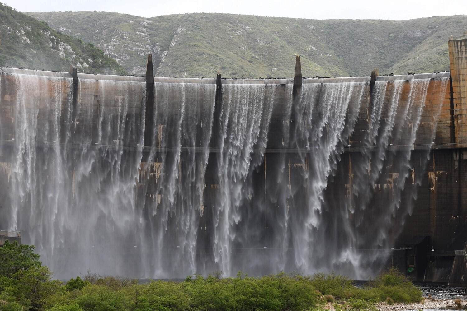
On Thursday, 7 May, the Department of Water and Sanitation (DWS) confirmed that Kouga Dam had reached 120.6% of its storage capacity, with peak outflows recorded at 2 491 cubic metres per second, equivalent to a one-in-50-year flood event.
Department spokesperson Wisane Mavasa said the dam remained structurally sound and was functioning exactly as engineers had designed it.
“Kouga Dam is a 72-metre-high double-curvature concrete arch dam equipped with an uncontrolled spillway and two radial gates.”
Mavasa explained that the spillway alone can discharge more than 6 100 cubic metres per second before reaching the non-overspill crest, more than double the flow at the time of the statement.
“Even in the unlikely event of overtopping, the integrity of the dam would not be compromised,” she said.
The department chose not to operate the dam’s radial gates due to Alkali-Aggregate Reaction in the concrete, a condition that causes swelling and could prevent the gates from closing safely.
Mavasa said this precaution was deliberate.
“Operating the gates under these conditions may create challenges in safely closing them, potentially resulting in permanent loss of storage capacity,” she said, confirming that the uncontrolled spillway was more than sufficient to manage current flows.
Mavasa said the department was continuing to track all developments.
“The Department continues to closely monitor inflows, reservoir levels, and the dam’s structural behaviour,” she said, urging downstream communities to remain cautious as river levels were expected to stay elevated during spilling.
Broader Algoa system transformed after weeks of drought stress
The broader Algoa Water Supply System has seen a dramatic turnaround following the rainfall.
As recently as 4 May 2026, the system’s overall surface water storage had dropped to just 35.6%. Within 48 hours, that picture changed entirely. Churchill Dam reached 115% of capacity, Loerie Dam 119%, Impofu Dam – now reported at 110% on Friday morning – and Groendal Dam at 72%.
Mavasa noted the significance of the recovery for a region grappling with serious water security concerns.
“The other dams in the Algoa Water Supply System have also made a huge upsurge in the last 48 hours to almost full recovery,” she said.
The department reassured the public that Kouga Dam “remains safe, stable and fully operational, and that all necessary measures are in place to protect downstream communities”.